The rediscovery by cities of their abandoned waterfronts has been one of the most important trends in urban planning and development in the past 30 years. First seen in American and European cities, projects like Battery Park City in New York and Canary Wharf in London brought the cities to their edges by bringing development, open space, and public access right up to the water. These projects have since become templates for cities around the world.
Related: ULI Case Study: Arverne by the Sea | Register for ULI Fall Meeting
Recently, the devastating effects of Hurricane Sandy have spurred recognition of the very real risks posed by climate change, calling into question the relationship between the city and the sea. According to the Intergovernmental Panel on Climate Change, more frequent incidents of heavy precipitation and increased risk of major storm surges are chief among the impacts that will result from climate change. The U.S. Army Corps of Engineers estimates that sea levels in the New York metropolitan area will rise from ten to 32 inches (25 to 81 cm) in the next 40 years. The aftermath of Sandy ratcheted up speculation and long-range planning on how best to deal with these looming threats.
However, consensus on a new paradigm for how coastal communities should adapt to changing conditions at the water’s edge is far from established. On one hand, the dire predictions related to climate change have prompted calls for retreat from the water’s edge. On the other hand, in cities like New York where nearly 400,000 people reside within the 100-year floodplain, living by the water continues to be an attractive prospect—and market pressures continue to fuel new waterfront development.
What is certain is that an array of approaches must be factored into the development and design of new and existing waterfronts, addressing how to incorporate the infrastructure of coastal protection in new development; retrofit existing communities to allow them to address vulnerabilities; and, in some cases, manage retreat from the water’s edge. Many of these techniques have been used in coastal communities for generations. The diversity of New York City’s 520-mile (837 km) coastline offers a window into how various coastal conditions may be addressed.
In denser urban settings, the Battery Park City model still offers important lessons for dealing with climate adaptation. At Battery Park City’s South Cove, for instance, a two-level system of waterfront walkways acknowledges the pull—and peril—of waterfront living. A lower level affords people close contact with the water’s edge, while a promenade at a higher level provides sufficient height to keep buildings out of the floodplain.
In Washington, D.C., the Wharf, a $2 billion redevelopment by PN Hoffman & Associates, Madison Marquette, and the District of Columbia that is underway along the Washington Channel, shows how this model can evolve to address the prospect of increased precipitation. The design calls for massive below-grade storage chambers to allow the site to accommodate storms that produce more than three inches (8 cm) of precipitation, and uses stormwater runoff as make-up water to compensate for loss from evaporation and leakage in the site’s cogeneration plant.
New York and other coastal cities are even studying the viability of preemptively engaging the water with new multipurpose levees that would be built on landfill to shore up protection of the upland areas that sit below the floodplain.
These “super levees” would incorporate new development to self-fund implementation and generate revenue to fund other resilience projects. (See “Rebuilding by Design” in the September 2014 issue of Urban Land.)

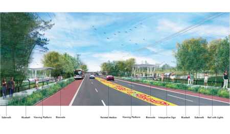
On Staten Island, the NY Rising Community Reconstruction Program has proposed integrating the New Creek Bluebelt into the public realm along Hylan Boulevard, the main commercial corridor of the borough. This would increase public awareness of the Bluebelt and the probability that it will be properly maintained. (Perkins Eastman)
In the New York Rockaways, an 11-mile-long (18 km) peninsula south of John F. Kennedy International Airport, a fragile beachfront environment, low-lying elevations, and the absence of drainage infrastructure created the setting for some of the worst damage inflicted by Sandy in New York City. The storm washed away significant sections of the peninsula’s boardwalk; undermined 400 feet (122 m) of track, halting subway service to the area for months; closed several schools; and caused a fire that destroyed hundreds of homes. One area that survived relatively intact was Arverne by the Sea, a 120-acre (49 ha) mixed-use public/private redevelopment. Arverne by the Sea integrated a robust combination of protective dunes, extensive new subsurface drainage and storage infrastructure, and new fill that elevated large parts of the site above the floodplain into a larger design strategy oriented around transit to create a community that is resilient on multiple levels. Arverne by the Sea demonstrated that resilient development along the water’s edge can be done in a way that enhances rather than detracts from its surroundings and increases rather than cuts off access to the water. Because the area had been neglected for decades, large-scale redevelopment was the linchpin in attracting badly needed private investment there. The resulting investment in roadway and drainage infrastructure had benefits for the resilience of the wider community and economic development of the wider area.
In New York City’s lower-density coastal communities like Staten Island, where private development outpaced the construction of drainage infrastructure, more frequent and severe rainstorms have made stormwater flooding a major issue. The New York City Department of Environmental Protection (DEP) is making major efforts to retrofit these communities with stormwater management systems called “bluebelts.” Bluebelts are composed of natural drainage corridors such as streams, ponds, and wetlands that are integrated with wildlife habitats and open space. The most ambitious of these projects can be seen along the eastern shore of Staten Island, where the DEP is acquiring land to implement the Mid-Island Bluebelt, and in southeast Queens, where the city is spending $175 million on the Springfield Gardens Bluebelt. These projects are envisioned as fingers of green and blue that extend into upland areas, storing, filtering, and eventually carrying water back to the sea. If, as some have proposed, the bluebelts can be integrated into the public realm, they have the potential not only to protect but also to add value to the surrounding communities.

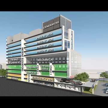
Changing conditions in waterfront areas will affect how critical facilities such as hospitals are designed. Historically, hospitals were typically located in—at the time, marginal—waterfront areas, which provided a suitable distance between patients with contagious diseases and the general population. Many of these hospitals today find themselves in highly vulnerable areas close to the water’s edge. As a result of Sandy, five hospitals in New York were forced to evacuate and remained closed for extended periods, resulting in hundreds of patients being evacuated or transferred and over $1 billion of property damage. In response, New York City hospitals have been studying new strategies to allow their key facilities to maintain operations in the face of severe weather events and rising sea levels. These measures range from erecting perimeter floodwalls to rethinking fundamental tenets of how hospitals are organized, such as locating the emergency department on the second floor and raising the power plant. (Perkins Eastman)
In some high-risk areas, a strategy of “managed retreat” has been pursued. While increasingly prevalent in Europe, managed retreat has been rare in the United States because of political sensitivities regarding property rights. According to Rebecca Sinclair, director of acquisitions and buyouts for the New York State Governor’s Office of Storm Recovery (GOSR), managed retreat has been considered in areas with no long-term viability due to exposure to environmental threats and where the community at large would benefit from retreat. Sinclair emphasized that managed retreat has been pursued only where overwhelming consensus was achieved on the need for buyouts and communities actively sought them out. On Staten Island’s eastern shore, which suffered 24 fatalities as a result of Sandy, GOSR has agreed to buy out 600 residential properties in the Fox Beach, Graham Beach, Oakwood Beach, and Ocean Breeze neighborhoods. These properties will be turned into open space and eventually incorporated into the Mid-Island Bluebelt system.
As New York continues to rebuild two years after Hurricane Sandy, it is clear that the longer-range challenge of rethinking, replanning, and redesigning the area’s coastal and waterfront areas is just beginning. Given long-term projections and impacts that are already being felt, these challenges are going to require massive resources and a renewed focus on how the city engages the water. While new strategies are being explored, integrated and holistic design strategies will remain central to creating more resilient communities along the waterfront.
Eric C.Y. Fang is an associate principal at Perkins Eastman, which led community reconstruction plans for the New York State Governor’s Office of Storm Recovery. Formerly, he was with EE&K (which has since merged with Perkins Eastman), the design architect for Arverne by the Sea.


