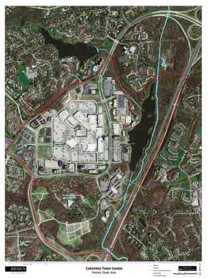
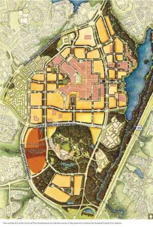
When the Howard Hughes Corporation (HHC) inherited control of the pioneering mixed-use town center of Columbia, Maryland, in 2010, the company became steward of the task of urbanizing Columbia’s still-suburban downtown for a city that had grown to a population of 99,615.
In the 1960s, developer James Rouse had conceived of Columbia, which was to be built on open land between Baltimore and Washington, D.C., as a 14,000-acre (5,700 ha) new town of ten villages, including its designated Town Center. The vision was roughly based on Rouse’s native Easton, Maryland, although Easton was a mid-19th-century village built on a rectilinear street grid of mostly 200-by-400-foot (61 by 122 m) blocks.
Instead of laying Columbia out as a grid, chief planner Morton Hoppenfeld followed the planning trends that were popular in the 1960s: he created curvilinear village pods which were separated by the stream valleys the developer was committed to preserving, using the overlay model explained by landscape architect Ian McHarg in his 1969 book Design with Nature.
Original Town Center
Three four- to six-lane divided-median parkways define the 400-acre (162 ha) Town Center and divide it into three loops around three major areas—the Columbia Mall, the Lake Kittamaqundi lakefront, and Symphony Woods. Elevation changes further separate the areas. The mall occupies the high ground about 60 feet (18 m) above the lakefront and 30 feet (9 m) above the parkway that separates them.
Envisioned by enclosed-mall pioneer Rouse to serve as the Main Street of Columbia, the mall was built in 1971, only four years after Columbia opened, to pre-service the city and its environs. Surrounded by inner- and outer-ring roads, the mall is still a primary economic driver. It contains 1.4 million square feet (130,000 sq m) of retail space that includes more than 215 shops and restaurants supported by 7,200 parking spaces serving a population of 870,000.
Rouse built the 35-acre (14 ha) Lake Kittamaqundi on the Little Patuxent River at the eastern edge of downtown. A two-acre (0.8 ha) plaza and a lakefront amphitheater only 750 feet (230 m) from the mall act as the civic heart of the city, centered on its 3,400-foot-long (1,000 m) lakefront.
From Columbia’s inception, the ten-story American City Building, an office structure located at the lakefront and flanked by restaurants, a hotel, a cinema, and a shared parking lot, signaled that a mixture of uses would be sought reasonably near each other, unlike in typical suburban centers at the time. However, the only pedestrian link between the downtown civic and economic centers is a slender pedestrian bridge that starts at the American City Building, traverses the six-lane Little Patuxent Parkway, and climbs the elevation rise to link to a path that goes around another office building, then crosses the inner-ring road to reach a tertiary mall entrance.
The third major loop of downtown, the 150-acre (61 ha) Merriweather District, is built around the ten-acre (4 ha) Merriweather Post Pavilion, accommodating 20,000 patrons and surrounded by the 30 acres (4 ha) of Merriweather Park at Symphony Woods. The pavilion, park, and additional protected open space occupy about half the district, but its central location shifts future development to its peripheral crescent. A four-lane parkway also divides Merriweather from the other two districts, but the southern-sloping grade change is more gradual than between the mall and lakefront.
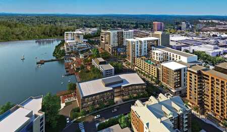
HHC’s decision to pay $16.5 million for the ten-story American City tower opposite the mall only to demolish and replace it with larger-scale urban mixed-use projects, such as those depicted here, substantiates its strategy to intensify lakefront development. (Design Collective, courtesy Howard Hughes)
The Urban Challenges
As a city planned to have a town center with a broad mix of retail, office, hotel, entertainment, educational, cultural, and civic uses within its central zone, Columbia is different from many suburbs. But the planning decisions—to forswear a rectilinear street grid, to break up the downtown with multilane parkways, to concentrate the retail heart in an enclosed mall, to have a paucity of urban housing, and to build at an automobile-centered, set-back building scale—present Columbia with challenges common to many suburbs seeking urban retrofits. The mall, lakefront, and pavilion remain physically and functionally separated.
HHC now has approval for about 13 million square feet (1.2 million sq m) of new downtown development, roughly half the size of downtown Baltimore, including an additional 5,500 market-rate residential units, 900 units of affordable housing, 4.3 million square feet (399,000 sq m) of new office space, 1.3 million square feet (400,000 sq m) of new retail space, and 640 new hotel rooms. Greg Fitchitt, HHC senior vice president of development, says the result will be a “21st-century urban village.”
This program adds to the current downtown, which contains the 1.4 million-square-foot (130,000 sq m) mall; 900,000-square-foot (84,000 sq m) Symphony Overlook offices; the former 100,000-square-foot (9,300 sq m) Rouse headquarters (the building, designed by Frank Gehry, now houses a Whole Foods, spa, and office space); the 120,000-square-foot (11,000 sq m) American City Building; a variety of other small office buildings; a 228-room Sheraton hotel; and the 530-unit Columbia Town Center Apartments, along with a mixture of medium-density condominiums and townhouses.
Downtown Columbia Plan
The Rouse Company had acquired HHC in 1996, then General Growth Properties (GGP) bought Rouse in 2004. GGP spun off HHC as a public company in 2010 when it exited its 2008 reorganization bankruptcy.
HHC inherited the Rouse town center properties, except for Columbia Mall and the 725,000 square feet (67,000 sq m) of office space and 3,000 parking spaces in six buildings south of the mall; HHC in December 2014 paid GGP $130 million for the six office buildings. Control of developable downtown land and the majority of developed space by a single developer is a characteristic shared with suburban redevelopers, but not typically enjoyed by their urban counterparts.
As ownership changes were being completed, the Howard County planning department held a ten-day charrette in 2005, facilitated by Baltimore-based architects Design Collective, to initiate a master plan for downtown Columbia. Design Collective partner Matt D’Amico notes that it was a broad-based public charrette with more than 1,000 participants, including downtown property owners, county representatives, elected officials, nonprofit organizations, and residents.
That effort culminated in the county’s adoption of the 2010 30-year Downtown Columbia Plan, which recites Rouse’s vision: “Downtown Columbia will be a diverse, mixed-use, livable, physically distinctive, and human-scaled place with a range of housing choices and recreational, civic, cultural, and educational amenities.” The plan notes that though Columbia had been successful in attracting a wide spectrum of uses for people with a broad range of incomes, the downtown is “still primarily suburban in nature . . . sparsely populated . . . automobile-dependent” and separated by vehicular thoroughfares.
To start retrofitting downtown to create a mixed-use, dynamic, walkable downtown, the plan defines six neighborhoods within the three loops around the mall, lakefront, and woods. A modified street grid articulates 21 blocks of various sizes around the mall, 13 lakefront blocks around the waterfront plaza, and four large blocks that occupy a crescent west and south of the pavilion and woods. Framework plans define land uses, streets, blocks, building heights, bicycle and pedestrian networks, and open space. In addition, the plan outlines policies for public facilities and sustainability programs.
The enhanced network of planned gridded streets is intended to define a more urban scale for buildings and streetscapes. The streets divide mall environs into development blocks and multiply potential links among the new buildings. Buildings are to be brought forward to the sidewalks.
Ring roads are to be transformed into urban streets. The planners seek to implement road diets to use road widths for bicycle and pedestrian movement as well as for vehicles. To replace the slender link between the lakefront and the mall across the divided parkway, planners envision a fountain terrace stepping down to channel gardens leading to the main waterfront plaza.
In January 2017, HHC acquired the American City Building for $16.5 million and plans to demolish it to make way for a denser mixed-use development with new office, multifamily, retail, and restaurant components in nine- to 15-story buildings on four parcels in the lakefront core.
Implementation Structures
The plan creates a system of downtown “community enhancements, programs, and public amenities” (CEPPAs). Enhancements include a variety of environmental assessments, site restorations, stormwater management measures, wetland enhancements, transportation and transit improvements, arts projects, infrastructure renovation, bicycle and pathway improvements, renovation of the pavilion and its dedication to the nonprofit Downtown Columbia Arts and Culture Commission (DCACC), dedication of a site for an elementary school, lakefront terraces, neighborhood squares, and affordable housing.
To implement the downtown plan, the county created the Downtown Columbia Partnership (DCP), an independent public entity that is the commercial district management authority separate from the county’s legislative and executive branches. It is governed by a seven-member board that includes the regional head of the HHC community developer, the Columbia Mall manager, the county executive, and the president of the Columbia Association, the nonprofit community services corporation that manages Columbia. The board has a wide variety of powers and essentially acts as a downtown business improvement district.
Funds to manage the partnership and the enhancements come from annual fees assessed on new commercial uses within the district in the amount of 25 cents per square foot ($2.69 per sq m) of gross leasable area for office and retail uses and net floor area for hotels. This amounts to about $150,000 per year, which is being supplemented by HHC and the Columbia Association but is expected to become self-sustaining as downtown Columbia continues to develop.
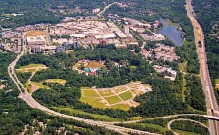
The enclosed mall (looking to the north) is still successful and economically viable. Restrictive parking covenants with department stores encumber large parking areas where new mixed-use development would logically be placed. As an alternative strategy, HHC chose to build urban neighborhoods on unencumbered land at the periphery of the mall. (Design Collective)
Affordable Housing
The county also created the Columbia Downtown Housing Corporation (CDHC) to implement affordable housing objectives. Development fees are assessed on developers before issuance of building permits on a sliding scale: $2,000 per unit up to the 1,500th unit of planned housing in downtown Columbia; then $7,000 per unit up to the 3,500th unit; and $9,000 per unit up to the 5,500th unit. HHC also contributed $3 million in seed funding to CDHC under the CEPPA requirements, paid with the fees on the first two new residential projects.
CDHC can use the proceeds to acquire land for affordable housing, for predevelopment studies, to make loans, or to pay housing operating expenses. The Downtown Columbia Plan conceives of a full spectrum and mix of downtown rental and for-sale housing. CDHC also can help families that meet income eligibility rules acquire primary housing.
In February 2017, HHC, the county, the Howard County Housing Commission, and the CDHC signed a 30-year binding agreement to replace the in-lieu development fees on rental units and instead provide 900 units of affordable housing downtown, including 400 inclusionary units dispersed in market-rate buildings; 417 units in mixed-income tax-credit projects; and 83 units in a live-where-you-work program, which provides rental assistance to qualified households. As a density bonus, the agreement exempts the 744 units, both affordable and market rate, to be built in tax-credit projects by the housing commission from counting against the 5,500-unit entitlement cap permitted to HHC.
Another implementing entity is the DCACC, to which HHC transferred ownership of the Merriweather Post Pavilion in November 2016. The commission manages arts, cultural, educational, and civic programming. Simultaneously, the county approved $90 million in tax increment financing (TIF) for public improvements to the Merriweather District, which will include in its first phase a shared 2,000-space parking structure, 1 million square feet (93,000 sq m) of office space, 250,000 square feet (23,000 sq m) of retail space, and 750 apartment units. In 2017, HHC completed 350,000 square feet (33,000 sq m) of space in two new office towers in the district—new education offices for Pearson Connections and a corporate headquarters for health care company MedStar.
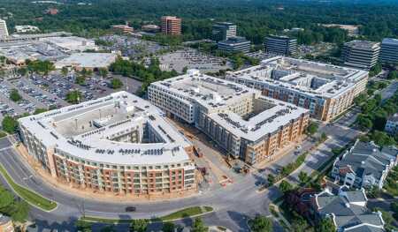
While formulating the outside-in strategy, HHC was able to see an opportunity closer to the mall. The Warfield area west of the mall consisted of several large parking lots, an office building, and small retail outbuildings just outside the ring road. The downtown plan projected that this ten-acre (4 ha) open lot should be reorganized into three smaller blocks (shown below on the map). Each block of the Metropolitan complex (above) contains a central parking structure, wrapped with single-loaded-corridor units to conceal it, as well as landscaped courtyards that contain pools and other amenities. The southern building (at right in the photo above) was the first built and is the largest, with 380 smaller units. The middle building contains 170 larger units, and the northernmost contains 267 units. (Design Collective)
Development Strategy
Defining the appropriate development strategy is critical to the success of transforming a suburban development into an urban downtown. Commonly, a dying mall is at the heart of the development, and if that is the case, the easiest starting point, if it is possible, is usually to close the mall and extinguish its restrictive covenants.
A mall is typically an agglomeration of 50 to 150 acres (20 to 60 ha) of land in a single zone, owned by a single entity (except for department stores that own their own sites) in a visible location, served by good access roads, with large structures that can be demolished or sometimes adapted. The site is usually easily divisible into a rectilinear block pattern. (An office park with similar characteristics might be suitable for such transformation as well.) In those situations, one could simply superimpose a street grid, start development at the core, and phase the growth outward.
But downtown Columbia presents a different array of development challenges. The enclosed mall is still economically viable. In addition, the critical mass of retail space needed to sustain the mall’s success challenges the market for new streetfront retail on a scale that would be common in an urban downtown. Restrictive parking covenants with department stores encumber large areas where new mixed-use development would logically be placed. The capitalized value of the income stream makes the mall too valuable to be demolished and replaced with more-urban streetfront retail space. The opportunity costs are enormous.
So instead, HHC chose to build urban neighborhoods on unencumbered land at the periphery of the mall at a scale necessary to be viable on their own, then to work toward the current center of Columbia at the mall. At full buildout, just one of those neighborhoods, the Merriweather Crescent, alone will constitute a dense urban neighborhood of nearly 5 million square feet (465,000 sq m) of new development, including more than 2 million square feet of office space (186,000 sq m) and 2,000 apartments, plus shops, restaurants, hotels, and the new central branch of Howard County’s public library.
HHC’s decision to buy the American City Building opposite the mall only to demolish and replace it with larger-scale urban mixed-use projects substantiates the company’s strategy to intensify lakefront development. And because GGP, not HHC, owns the mall, HHC’s strategy is to create vibrant new urban cores on the southern and eastern flanks of the retail core, then link those back to that core.
From a development perspective, creating and controlling new urban cores on open land is more productive than trying to overcome the physical, legal, and financial challenges of developing on more restrictive properties. Moreover, those intermediate properties will become more valuable later when alternative cores flank them, which will make it easier economically to develop them in later phases.
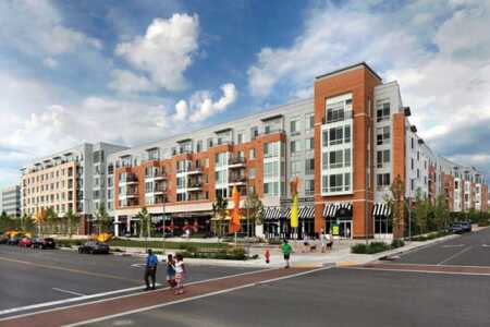
The western mall ring road has added the Metropolitan complex. Retail space lines and activates the streetscape on the first floor of each building facing the mall. The space is leased to service retail tenants and restaurants that face the ring road, which has been transformed into a commercial street with on-street parking, sidewalks, and pedestrian crosswalks. (Design Collective)
The Metropolitan
While formulating the outside-in strategy, HHC also saw an opportunity closer to the mall. The Warfield area west of the mall consisted of several large parking lots, an office building, and small retail outbuildings just outside the ring road. The downtown plan projected that this ten-acre (4 ha) open lot should be reorganized into three smaller blocks of two-to-four acres each (0.8 to 1.6 ha) with new connecting streets.
HHC determined that about 800 housing units could be developed in three buildings on the three blocks, but decided that for its first downtown Columbia residential project, it would team up in a joint venture with the Kettler Company, a large East Coast apartment developer/manager based in McLean, Virginia. HHC and Kettler hired Design Collective. The three parties determined that each block would contain a central parking structure, wrapped with single-loaded-corridor units to conceal the parking, and landscaped courtyards with pools and other amenities. Double-loaded corridors face the courtyards and the streetscape.
To accommodate their quasi-urban location in downtown Columbia, each of the parking structures is a modified shared-use garage, with the bottom one-and-a-half floors reserved for retail parking. Exclusive residential parking is on upper floors; residents can park on their respective apartment levels and avoid elevators. Because parking is allocated by use, it is not yet fully shared parking that could reduce parking ratios. Ground-floor retail space lines and activates the streetscape on the mall ring road, which has been transformed into a commercial street with on-street parking, sidewalks, and marked pedestrian crosswalks.
Opposite the mall, across from older apartment buildings and townhouses, the Metropolitan, the first of the three-residential-building complex built, has ground-floor units that include stoops, stairs, unit entrances, and garden walls, mimicking the stoops and stairs of existing buildings across the street. A linear landscaped park about 80 feet (24 m) wide lines the eastern, retail side of the three buildings. In addition to playful sculptures and street furniture, the park contains a stormwater management system that integrates with the larger districtwide strategy. Signs inform park users of the project’s sustainability goals, the environmental benefits of micro-bioretention, and the benefits of districtwide water management.
The Metropolitan, the southern building, is the largest of the three residential buildings, with 380 mostly smaller units that have been leased to younger professionals. Empty nesters mainly chose the 34 available three-bedroom units. The building on the middle block contains 170 larger units to attract different market segments, including empty nesters, retirees, and single people, and the northernmost building contains 267 units, including the first studio units in downtown Columbia. These 817 apartments, with 45,000 square feet (4,200 sq m) of streetfront retail space, establish a prototype for redevelopment of mall parking lots.
Suburban Urbanization Model?
D’Amico notes that the 16-step process to implement the 2010 plan is intricate. However, he contends that it is essential that the various frameworks for streets, blocks, land uses, density, and open space be followed in order to ensure that a true downtown can be created. Projects must conform to the Downtown Columbia Plan, neighborhood plans, and design guidelines. In addition, the policies and programs for affordable housing, arts and culture, sustainability, and community enhancements are precisely the things that can make a downtown culturally authentic and distinguish it from suburban development, he says.
Those community networks are the very things that James Rouse sought when he conceived Columbia and may well count for its designation by Money magazine in 2016 as the nation’s most livable city, with exceptional economic opportunity and social diversity 50 years after it was first developed. Perhaps the process that Columbia now follows to transform its largely suburban core into an urban-scaled downtown may also become a model for retrofits in other suburban areas.


