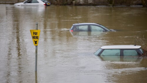
In 2013, Toronto had record-high rainfall and flash flooding that overwhelmed urban stormwater and river systems, and ultimately caused an estimated $940 million in damage payouts. In 2019, Lake Ontario experienced record lake level conditions. Lake Ontario is following a similar upward trend as that seen in many of the Great Lakes. Toronto’s downtown is located just west of the mouth of the Don River, which is the culminating point of a significant river system that flows through many municipalities.
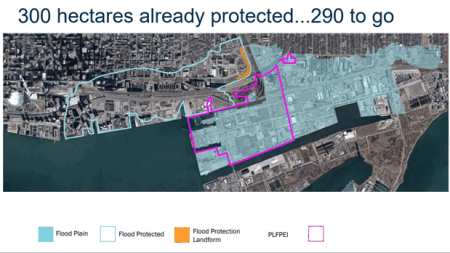
At the confluence of the Don River and Lake Ontario is almost 600 hectares (1,500 sq m) of floodplain located about two kilometers (1.24 miles) from Canada’s financial center. “The area has some significant flood considerations that must be considered. We are trying to create a resilient community at the mouth of the River,” explained Ken Dion, project director of Port Lands integration for redevelopment agency Waterfront Toronto.
This webinar is available on demand on ULI Knowledge Finder.
Waterfront Toronto is in the process of transforming this vulnerable site to both revitalize the city’s eastern waterfront and manage flood risk.
This attracted ULI Coastal Forum participants to learn more, since it offered valuable lessons that can be transferred to other coastal markets. The Coastal Forum is a member‐initiated network of leaders in real estate, land use, and climate resilience interested in sharing best practices for coastal development.
Meeting virtually instead of in person in Toronto, the forum took part in a webinar and a virtual walking tour of two innovative projects in Toronto: Corktown Common and the Port Lands. The walking tour included recently captured drone footage of the sites, narrated with information on project design and implications for the surrounding neighborhoods and development community.
During the webinar, Jack Smith, chair of the Coastal Forum and partner for law firm Nelson Mullins, said, “The Coastal Forum aims to answer questions like: What works and what doesn’t on our waterfronts? How can we protect long-term investments in real estate development on our coasts, and make them more resilient?”
The forum typically convenes biannually in a dialog‐based setting to address questions like these, share tools and resources, tour innovative projects, and analyze trends relevant to climate-resilient waterfront development.
Corktown Common is the “first phase” of the floodproofing of the area, a seven-hectare (17 ac) award-winning park in the West Don Lands that opened in summer 2014. Peter Preston, a civil engineer for Arup, presented the park to the forum. “It formed a cornerstone of the area’s revitalization at the mouth of the Don River.”
The park includes several amenities such as a large pavilion, a splash pad, a sandy playground, a dog run, walking trails, and the city’s first artificial marsh, which supports the area’s ecology and natural habitats. “It has become a destination within the city,” Preston said.
Arup followed several principles that centered on a “design with water” approach, which included minimizing potable water use, reusing graywater, and designing spaces that would reconnect people with the waterfront.
Corktown Commons uses a closed-loop water recycling system by leveraging components of the park’s design and features. “A hidden element is a 900-cubic-meter underground.” Preston continued, “The cistern collects the surface stormwater and overflows from the marsh, which is then redirected to parkwide irrigation.”
Corktown Common was integrated into a larger Waterfront Toronto flood protection project that, among other design aspects, called for a large landform that reaches four meters (13 ft) in height. The park and this berm-like structure ultimately removed areas as far west as the financial district out of the floodplain.
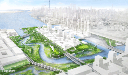
Nearly adjacent to Corktown Commons, the Port Land project is centered on creating three more resilient outlets for the Don River to flow in a way that also unlocks developable land and forms park space and wetlands. Don Forbes, project director for soil remediation and earthworks of Waterfront Toronto, led the virtual walking tour through eight features of the Port Land protection project including future river valleys, roadways and greenways, development sites, and necessary infrastructure installations.
Forbes shared, “We are actually creating a naturalized river system that will effectively be creating two islands, a series of adjacent wetlands, and riparian areas, tied in with parklands and ultimately development areas.”
#RockyRadar: I’ve now officially dug over 800 metres of slurry walls. I could use a long weekend. pic.twitter.com/UeJgqHXhiZ— Rocky (@TheRockRipper) May 15, 2020
Waterfront Toronto is counting on realizing multiple benefits from the Port Lands project design, including benefiting natural ecology, improving resident recreation opportunities, and providing flood relief. Dion shared, “The intent of [Port Land’s design] is to eliminate flood risk up to the regulatory flood but also an additional 50 centimeters [20 in] of freeboard to help deal with the uncertainty of climate change and other factors.”
Mira Shenker, senior manager of communications and public engagement for Waterfront Toronto, spoke encouragingly about the “potential of spaces” and how the flood protection work unlocks opportunities for new and surrounding communities.
One of the islands in the Port Lands will become home to a mixed-use community, approved by City Council in 2017. To the east, plans call for light industrial and film uses to build on an established film district in the area.
Shenker continued, “There’s a real potential that sprouts up when remediating these previously industrial spaces . . . starting with the public realm, like in the Port Lands.”
Key to revitalizing Toronto’s waterfront is enhancing the resilience of these areas for current and future flood risk. When Spring Meeting returns to Toronto in 2023, the Coastal Forum welcomes other ULI members to join them in exploring the Port Lands, Corktown Commons, and Toronto’s eastern waterfront. If members are interested in participating in upcoming Coastal Forum engagements, please fill out the ULI Navigator form.


![Western Plaza Improvements [1].jpg](https://cdn-ul.uli.org/dims4/default/15205ec/2147483647/strip/true/crop/1919x1078+0+0/resize/500x281!/quality/90/?url=https%3A%2F%2Fk2-prod-uli.s3.us-east-1.amazonaws.com%2Fbrightspot%2Fb4%2Ffa%2F5da7da1e442091ea01b5d8724354%2Fwestern-plaza-improvements-1.jpg)


