From smuggled cigarettes to illegal billboards and overcrowded homes, Chicago-based CityScan uses technology to identify a variety of infractions, which could lead to millions of dollars in revenue for cities.
Founded in 2011, the tech startup builds extremely detailed models and maps of urban areas. Synchronizing the data with zoning information and permit information, experts from CityScan can flag potential scofflaws.
“CityScan is an inspector,” says Orlando Saez, chief operating officer for CityScan. “We inspect, we observe, and we predict.” Because these inspections take place virtually rather than in person, hundreds of man-hours in initial site visits can be avoided. This allows cities to check on problems they would never have enough staff to identify otherwise.
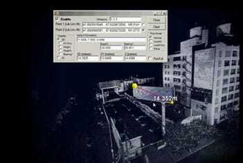
To build its maps, CityScan gathers huge amounts of information—some proprietary, some public. The biggest data trove—provided by NAVTEQ, a subsidiary of Nokia—is obtained with light detection and ranging (LIDAR) technology. A LIDAR system can collect millions of data points per second as lasers are projected, strike objects on the street, and are reflected to detectors. Each data point comes with its own global positioning service (GPS) coordinates. Connecting the dots provided by these data points, the system can draw outlines of everything in the built environment from buildings to billboards—even small objects like doorbells and mailboxes.
NAVTEQ collects the data using the same cars that capture streetscape video images for Microsoft Bing’s StreetSide service. NAVTEQ has LIDAR data for every street in every major city in the country. CityScan can also build data standards that combine information from many city agencies and add it to the map.
This creates an opportunity for cities to collect fees that property owners have neglected to pay. CityScan’s three-dimensional model of the street is exact enough to measure elements like the height of a construction fence or the square footage of a billboard; public-agency information shows the permits issued for such elements. Putting the two together, and CityScan’s inspectors can make a list of probable infractions for city inspectors to pursue.
CityScan can even help identify overcrowded single-family homes. CityScan’s inspectors can note extra mailboxes and doorbells in front of homes on their virtual “drives” through the three-dimensional map.
Not all of CityScan’s initiatives start with LIDAR; the company has patented an idea to help catch cigarette smugglers, in part by comparing information available online that shows where cigarettes are being sold, with public records that show who is selling cigarettes that are taxed according to the law. The difference between those two data sets often leads to smuggled cigarettes. The additional revenue for jurisdictions with high cigarette taxes can easily add up to millions of dollars a year, according to CityScan.
CityScan is also helping towns complete a seemingly impossible task. Federal officials now require all traffic signs to meet new standards for reflectivity—a way of keeping the roads a little safer as the population ages. Reflectivity is not LIDAR’s strongest suit, but the lasers still gather enough information to knock a significant number of street signs off the list inspectors need to check, either because they clearly meet the standard for reflectivity or because they clearly do not. “Cities can save millions because you don’t have to drive to check every sign,” says Saez.
Too Much of a Good Thing?
All this information can create a new problem: once CityScan sends officials a stack of leads relating to likely infractions, local officials may need to check the leads the old fashioned way—in person. Many cities lack enough inspectors to respond immediately.
The worst-case scenario for a city would be to have more information on potential scofflaws—scaffolding at building sites without permits, for example—than inspectors can realistically follow up on. Simply having that information sitting on an overworked inspector’s desk could make a city liable if there were an accident. So CityScan can pace the information it provides to local officials. “They say not to send them more than 50 [possible infractions] a week,” says Saez. “If we send 500—which we can do—they are flooded.”
Also, there could be a backlash if city officials suddenly were to issue large fines for violations of laws that had not been enforced for years and may have been forgotten. “Before you enforce, you have to inform,” says Saez.
CityScan - Be smarter harnessing the power of outdoor intelligence from Orlando Saez on Vimeo.
cityscanbbdc v2 from Orlando Saez on Vimeo.


